
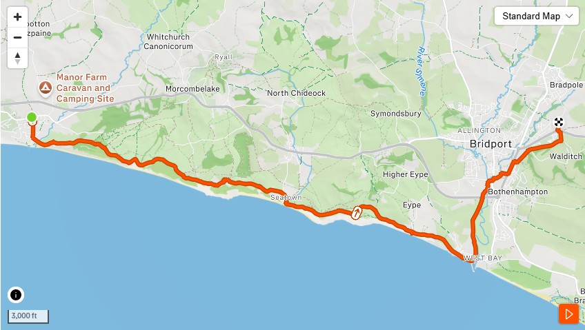
This route has been mapped. It hasn’t been walked as a group yet. What it has going for it — apart from ten miles of the finest coast path in Dorset, Golden Cap, Thorncombe Beacon, and a finishing point with one of the best historical jokes in the county — is a story. Specifically, the story of a 21-year-old king who ran this coastline in September 1651 with Cromwell’s army looking for him, and made it out by the skin of his teeth via a lane in Bridport that now bears a stone in his honour.
King Charles II walked this way. We plan to follow. He was considerably more motivated.
What the route does
The route starts at Charmouth and finishes at the Lee Lane stone in Bridport — ten miles of point-to-point walking along the South West Coast Path, dropping into West Bay before heading north along the River Brit into town. Number of walkers / runners will dictate how many cars will be required at each end. Additional Journeys, if required, will be made while you have a well earned pint at the end.
Out of Charmouth the path climbs west onto the clifftop above Lyme Bay. The coast opens up immediately — the kind of view that makes clear why people have been walking this coastline for centuries. The South West Coast Path here is well-marked, well-walked, and in July, well-populated. In September 1651, considerably less so.
The coast path heading west from Charmouth. Lyme Bay behind, the cliffs ahead. Charles came this way in the dark.
The route climbs to Golden Cap — at 191 metres the highest point on the entire south coast of England. The name comes from the layer of greensand that caps the summit and turns gold in certain light. On a clear day the views extend from Portland in the east to Start Point in Devon to the west. On the day Charles II passed through, the weather was foul. He was travelling in disguise. He was not stopping for the view.
Golden Cap summit. 191 metres. The highest point on England’s south coast. Worth every step.
From Golden Cap the path descends to Seatown — a handful of cottages, a beach, and a pub that has been there in various forms since the seventeenth century — before climbing again over Thorncombe Beacon. Thorncombe Beacon is familiar territory if you’ve done the Colmers Hill recce: you can see it from the hill, and now you’re on it. The views back toward Bridport and Colmers Hill are a satisfying reversal of that earlier perspective.
Thorncombe Beacon looking east. Colmers Hill visible on the horizon. The route joining up.
The path drops down past Higher Eype and Eype’s Mouth — a narrow shingle beach at the foot of the cliffs — before the final clifftop section above West Bay. This is where the character changes. The drama of the open cliff gives way to something more domestic: the rooftops appear below, the harbour entrance, the boat masts. The descent into West Bay from the east brings you down onto the sea wall, past the rocks and into the harbour.
West Bay from the east cliff approach. The harbour below, East Cliff behind. The route’s halfway point.
From West Bay the route heads north along the River Brit — the Old Line — the same path through Bridport’s sculpture meadow that features in Route B. If you’ve done Route B you’ll recognise this section. If you haven’t, the sculptures in the riverside meadow are worth a pause. They tend to surprise people who are expecting a path and find an open-air gallery instead.
The Old Line path north from West Bay. The River Brit alongside. Bridport ahead.
The route ends at the top of Lee Lane, off South Street, where a stone has been waiting since 1901.
The history
On 23rd September 1651 — two years before his restoration, six weeks after his defeat at Worcester — King Charles II arrived in Bridport with a small party, disguised as a servant. The town was full of Parliamentary soldiers preparing to embark for Jersey. Charles walked through them. He stopped at what is now the Bull Hotel on East Street, where a groom recognised him and said nothing. Then, aware that the game might shortly be up, he rode out via Lee Lane heading east toward Charmouth — which is, in reverse, exactly the route we’ve mapped.
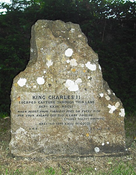
The stone at the top of Lee Lane reads:
KING CHARLES II ESCAPED CAPTURE THROUGH THIS LANE SEPR XXIII MDCLI
WHEN MIDST YOUR FIERCEST FOES ON EVERY SIDE FOR YOUR ESCAPE GOD DID A LANE PROVIDE (Thomas Fuller’s Worthies)
ERECTED SEPR XXIII MDCCCCI
The verse is from Thomas Fuller’s Worthies of England, written in 1662. The stone was erected on the 250th anniversary of the escape, in 1901. It has been standing quietly in the hedge at the top of Lee Lane ever since, waiting for someone to notice it. We noticed it.
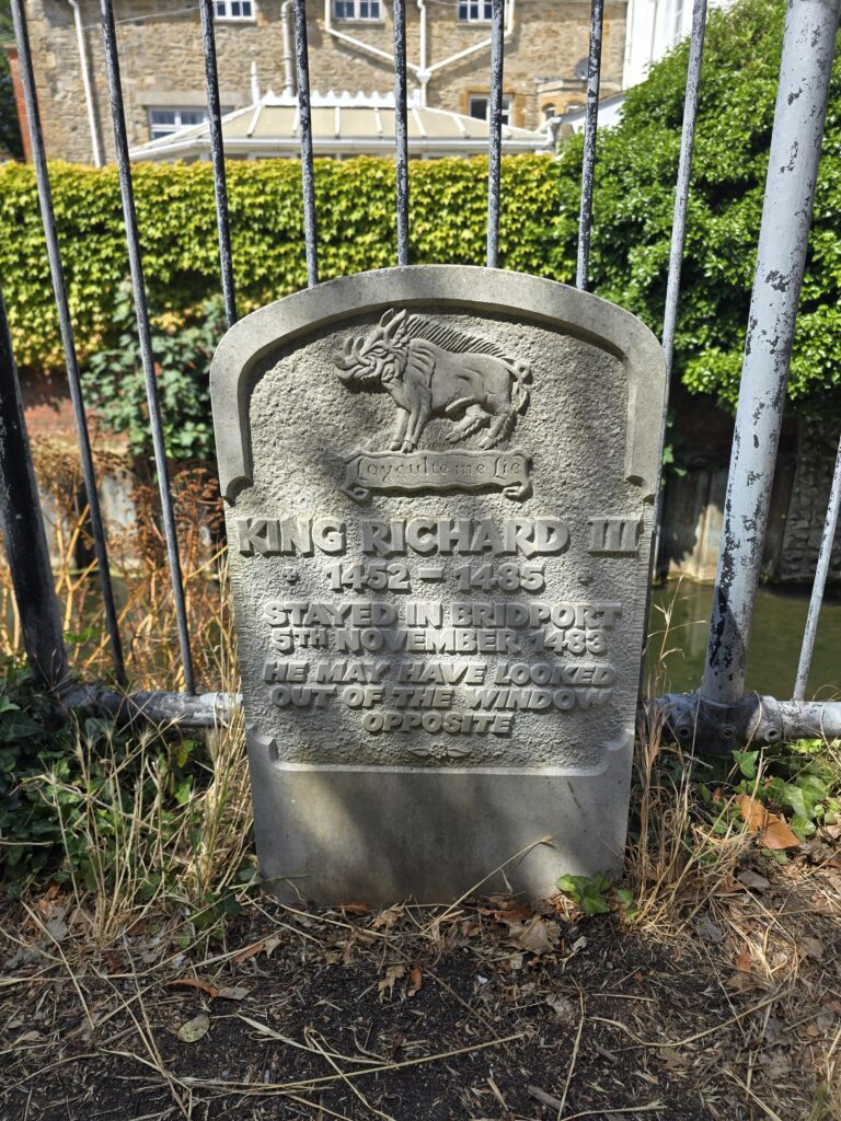
It’s worth adding that Bridport already has a stone for King Richard III — tucked against the river railings near the town bridge, noting that he stayed in town on 5th November 1483, and that he may have looked out of the window opposite. Two royal fugitive markers in one market town is, we think, a distinction worth celebrating.
The logistics
This is a point-to-point route. It does not loop back. Two cars minimum are needed.
Car one parks at Charmouth — the main car park on the seafront works well. Car two parks in Bridport, near the top of Lee Lane off South Street. The group travels together to Charmouth, walks to Bridport, and drives the second car back to collect the first. James and John between them have this covered.
The route is rated Hard on Strava. 2,126 feet of elevation over 10.14 miles is a genuine day out — Golden Cap and Thorncombe Beacon between them account for most of it. This is a walk, not a run, and should be treated as one. Allow four to five hours including stops. Pack lunch. The Anchor at Seatown is roughly halfway and has a beer garden. These two facts are not unrelated.
63% of the surface is unpaved. Trail shoes are strongly recommended. In wet weather, sections of the cliff path become slippery. The route is exposed in places and not suitable if conditions are poor.
What TOL looks like on a walk
Headphones off. Everyone moves at the pace of the person who needs it most. Nobody gets dropped at the back of a climb. Nobody charges ahead on a descent. The conversation is the point — ten miles of coast path gives you a lot of it.
The group regroups at Golden Cap, at Seatown, and at the stone. Those are the three natural stopping points and they’re spaced well. The history gets told at the end, not the beginning — arriving at the Lee Lane stone is better than being briefed about it at the car park.
If that sounds like your kind of day, the route guide will follow once the route has been walked and confirmed. I am almost certain we will squeeze in a Pint or Coffee, both en-route and at the end. That’s how TOL routes get made.